Author:
San Marcos Hays County Collection.
Imprint:[San Marcos, Tex] : [San Marcos Public Library], ca. 1960.
Physical Description1 map : b&w ; 60 x 45 cm.
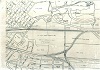
Note:This map was sent to City planners by the Missouri Pacific Railroad Company in 1960 during negotiations about building a bridge for the continuation of Hopkins Street east of the river. It shows plats of land and the existing railroads.
Note:The letter from Missouri Pacific RR is attached as a pdf.
Electronic Resource:Electronic resource:
http://www.hank.ci.san-marcos.tx.us/SMHC/Maps/map1960rail.jpg -- Materials specified: Photo
Electronic Resource:Electronic resource:
http://www.hank.ci.san-marcos.tx.us/SMHC/Maps/map1960railnote.pdf -- Materials specified: Photo
CitationA high-definition version of this image is available for scholarly or personal use by request from the library. It should be cited as "Photo reproduced from the San Marcos-Hays County Collection at the San Marcos Public Library."


)