Author:
San Marcos Hays County Collection.
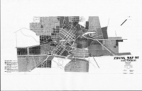
Imprint:[San Marcos, Tex] : [San Marcos Public Library], 1963.
Physical Description1 map : b&w ; 168 x 92 cm.
Note:This is a waxpaper master (reversed) for making a blue-line print. Fragile with sections already missing. Stored in a tube in Rm 3.
Note:A high-def pdf of the map in reverse is linked below, as well as a more legible jpg of the map (perspective restored).
Electronic Resource:Electronic resource:
http://www.hank.ci.san-marcos.tx.us/SMHC/Maps/1963 Zoning Map.jpg -- Materials specified: Photo
Electronic Resource:Electronic resource:
http://www.hank.ci.san-marcos.tx.us/SMHC/Maps/1963 Zoning Map--reverse.pdf -- Materials specified: Photo
CitationA high-definition version of this image is available for scholarly or personal use by request from the library. It should be cited as "Photo reproduced from the San Marcos-Hays County Collection at the San Marcos Public Library."


)